CLAY COUNTY – Hurricane Milton passed Clay County late Wednesday and early Thursday, leaving 4,500 customers without power and hundreds with more debris from trees and a threat of flooding from the …
This item is available in full to subscribers.
To continue reading, you will need to either log in to your subscriber account, below, or purchase a new subscription.
Please log in to continueDon't have an ID?Print subscribersIf you're a print subscriber, but do not yet have an online account, click here to create one. Non-subscribersClick here to see your options for subscribing. Single day passYou also have the option of purchasing 24 hours of access, for $1.00. Click here to purchase a single day pass. |


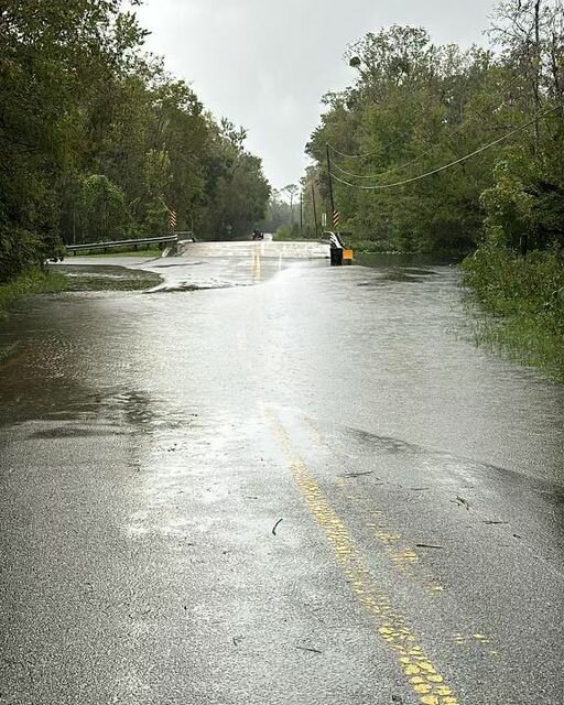


CLAY COUNTY – Hurricane Milton passed Clay County late Wednesday and early Thursday, leaving 4,500 customers without power and hundreds with more debris from trees and a threat of flooding from the Black Creek.
The massive storm steered further south than originally forecasted, sparing northern Florida but creating a devasting path of destruction in Central Florida and the West and Space Coasts.
Milton made landfall as a Category 3 hurricane at Siesta Key at 8:30 p.m. Wednesday and it left the state near Melbourne as a Category 1 hurricane shortly after midnight. But for a period of 12 hours before and 12 hours after the storm, Milton spawned a record 126 tornadoes in Central and South Florida, and strong winds continued along the shoreline, including gusts of 60 mph in Daytona Beach at noon on Thursday.
One stunning image of Milton’s wrath was the damage leveled at the 42,735-seat Tropicana Field in St. Petersburg. The storm's winds ripped away the dome's roof, home to the Tampa Bay Rays baseball team.
However, Clay County's concern was focused on Black Creek and the St. Johns River. Emergency Management officials were monitoring the North and South Prongs of the Black Creek and the St. Johns River since high tide was forecasted for 3 p.m. Thursday.
Because Clay County Animal Services is close to the Black Creek South Prong, most animals were relocated to the Clay County Fairgrounds. Volunteers are needed to walk dogs on Thursday and Friday.
“We're going to go ahead and start getting some crews out there to do windshield and damage assessments to see what the county looks like,” said Clay County Emergency Management Director Tim Devin. “I want to encourage you to either call in or put on our web any damage that you may have, down power lines, down trees damage to your home. Please let us know. That number to call is (877) 252-9362. Again, that phone number is (877) Clay EOC, and you can also put that on our web at alert.claycountygov.com.
“Our call center will remain open this morning, throughout the day, and into the evening. So, as we transition from shelters, we're going to start moving into host shelters, and we're still going to stay vigilant and prepared.
“Take into account that we're still going to see some of the weather throughout the day, and it should start subsiding about 6 to 7 o'clock this evening (Thursday). So, on the north and south prongs, please also let us know through our call center or the website if you're starting to see flood waters come up to the points that we normally watch.
“We're transitioning also may response phase more into a damage and recovery phase as well. So also watch our messaging on social media and on our website as we start moving back into the debris management from Hurricane Helene. If you have any additional downed trees or down limbs. Please ensure you're putting that up with waste that the damage is set or the debris crews can pick that up in a timely fashion.”
According to the National Weather Service, the highest recorded wind gust in the county was 49 mph in Green Cove Springs. Keystone Heights had gusts of 40 mph.
All Clay County schools will reopen on Friday, as will the Rosemary Hill Solid Waste Facility, county offices and city and town offices for Green Cove Springs, Orange Park and Keystone Heights.
County officials met with the Clay County District Schools and the Rosemary Hill Solid Waste Facility officials early Thursday, and they will announce later Thursday when they will reopen.
The four school shelters were closed on Thursday, but anyone still needing shelter will be accepted at the First Baptist Church of Middleburg, 2645 Blanding Blvd. According to the county, a record 76 evacuees were at the shelters, escaping the storm.
Please report any damage, like downed trees and powerlines, to our call center or online at alert.claycountygov.com. The call center number is 877-CLAYEOC.
There will not be garbage or yard waste collection on Thursday. Thursday’s routes will be picked up on Friday and Friday’s routes will be picked up on Saturday.
Disaster debris vendors will be picking up vegetative storm debris on Thursday.
Citizen vegetative debris drop-off is open at the Clay County Outdoor Adventure Park at 3829 Sgt. Bradley Crose Road in Middleburg. Residents can bring vegetative debris from 11 a.m. to 7 p.m., Monday through Saturday until further notice.
![]()